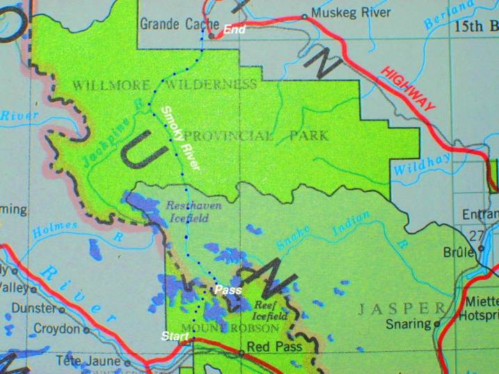
The focus of our expedition is the Canadian Rockies. We will drive into the shadow of Mount Robson, the highest peak in the Canadian Rocky Mountains. The Smoky River originates from the Glaciers around Mt. Robson at an altitude of just over 1600 m. It starts out as a very small creek draining Adolphus Lake, gaining volume with every Glacier it passes. The first parts are very steep and will involve some portaging around rapids. However we plan to run as much as possible, and will take whitewater boats. Pete Smolders is the Kayaker in our team and will take a high volume displacement hull on this trip. Tim Marks and Jan Dettmer will paddle solo whitewater canoes which, for sure, is a wise choice when we look at the gradient of the river, steep rapids, with glacial flats in between.
The trip will be completely self-supported for the estimated time of two weeks. This might not sound very long, but in fact, two weeks equipment, and food in whitewater boats can be a long time. Storage capacity, and weight, are our main concerns.
We start out right beside the Yellowhead Highway and will carry the boats, equipment, and food, to the headwaters. This involves a 25 km hike with an altitude difference of more than 1000 m. Since it is impossible to carry everything at once, we will have to do multiple trips to the pass.
Upon arrival at the headwaters, the whitewater trip starts. We will face the Smoky River, which flows for 120 km, through the wilderness of Jasper Park, and the Willmore Wilderness Park. The total gradient of the river over this stretch is roughly 800 m, the steepest parts being the first 50-60 km of 15 m/km. After that, the river has considerable volume and is less steep.
Was it done before? To our knowledge, only two parties in the last 20 years paddled the river. Last year, the staff of Wild Blue Yonder rafting company, rafted the river. However, both parties flew into the headwaters by Helicopter. The main idea of our trip is to do it by fair means, i.e. with muscle power only.
The trip will end in the town of Grande Cache, about 14 days after we started out on the other side of the Rocky mountains. By then we will have hiked and paddled through 140 km of wilderness and negotiated 2,000m of elevation change.